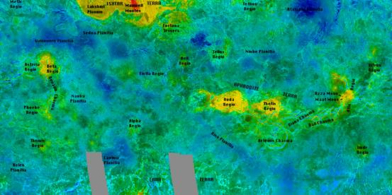
Planet Venus surface facts obtained by radar
Most of the topographical information about Venus’ surface was obtained by the Soviet missions Venera 15 and 16 and by the American space probes Pioneer et Magellan during the period 1978 to 1994. Our knowledge concerns about 98% of the surface.
The only way to penetrate Venus’ cloud layer is with radar, bouncing it back off the surface from an orbiting probe or even from the Earth. In fact, many images were obtained in the middle of the 70s with the giant antenna at Arecibo in Porto Rico giving a resolution of 12 cm.
The radar surveys indicate a varied terrain with:
- mountains
- plains
- high plateaus
- volcanoes
- crest
- impact craters
Venus surface color
The planet’s surface seems to be orange which could be due to oxidation identical to that seen on Mars.
Young and flat landscape
The age of the crust has been evaluated at 500 million years, which is young in the history of the solar system. Lunar continents are over 4 billion years old. The dating is done by counting the number of craters and the orbit of the planet. More craters mean an older surface. Venus reveals about 1000 impact craters.
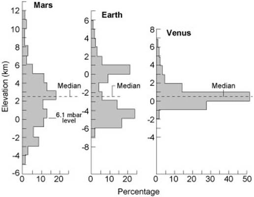
As there are no oceans on Venus there is also no ‘sea-level’ reference. Planetologists have taken the average planetary radius as a reference. This is 6051.84 km.
Globally, Venus is a fairly flat terrain; about 60% of the surface doesn’t rise more than 500m above the average level. Altitude variations are weak, about 2 to 3 km, except for a few mountainous regions. The ‘continents’ rise about 10 km, compared to a difference of 25km on Mars and of 20km on Earth.