Adapted from the NASA press release
A NASA Earth-observing satellite has helped researchers track carbon dioxide (CO2) emissions (sources) for more than 100 countries around the world. The pilot project offers a powerful new look at the CO2 emitted and removed (sinks) from the atmosphere by forests and other carbon sinks within national borders. The findings demonstrate how space-based tools can support insights on Earth as nations work to achieve climate goals.
We have one very big problem to solve, and the Paris Agreement aims to achieve just that, by setting goals for the reduction of CO2 emissions. There is another problem though: how can we monitor changes in CO2 emissions across all facets of a country’s economy?
Within the Paris Agreement, each country is responsible for the monitoring and reporting of greenhouse gas emissions and removals within their borders, based on sectors. These are called National Greenhouse Gas Inventories and are compiled and submitted annually by the countries to the United Nations Framework Convention on Climate Change. However, there are a few challenges with this bottom-up approach:
- More than 50 countries have not reported emissions in 10 years, leading to data gaps.
- Bottom-up estimates of CO2 emissions and removals rely on accurate and timely activity data and models that relate this activity data to net emissions or removals. These approaches can pose considerable uncertainties when activity data is lagging or not fully known.
- It is challenging for countries to check the accuracy of inventories aggregated to national totals.
In addition, the national inventories do not include emissions and removals of CO2 by unmanaged ecosystems (including parts of tropical and boreal forests) or by the ocean. These are important to quantify because:
- Concentration does not equal emission, because as CO2 is emitted into the atmosphere by both human and natural sources, it is also being removed from the atmosphere by oceans, lakes, plants etc., thus reducing the overall concentration of it in the atmosphere. The net emission has to be derived from the concentration data, and these CO2 inventories require considerable effort and expertise to compile.
- Unmanaged ecosystems like oceans, rainforests or remote locations are difficult to monitor and are not well accounted for, leading to significant data gaps in the global CO2 budget.
If we want to have any chance of limiting the consequences of climate change by keeping global warming below 1,5°C or even 2°C, precise knowledge of the CO2 budget is absolutely essential.
Filling in the gaps with the top-down approach
This is where the space-based and ground-based atmospheric CO2 data comes in. The inferred net emissions and removals of CO2 from these data are not only crucial for the validation of bottom-up methods, but it ensures a global coverage of even the remotest parts of the Earth.
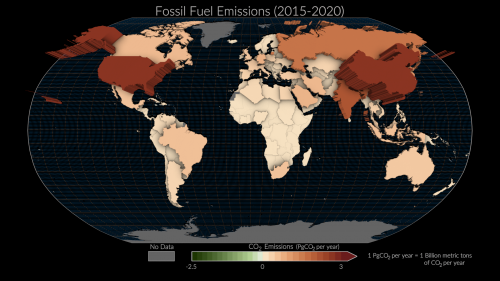
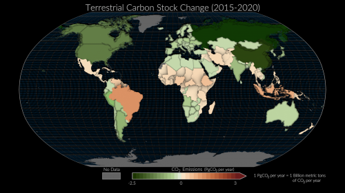
Scientists of the Royal Belgian Institute for Space Aeronomy (BIRA-IASB) have contributed data from a ground station on Réunion island to an international study, conducted by more than 60 researchers from around the world, which used satellite measurements made by the NASA’s Orbiting Carbon Observatory (OCO)-2 mission and a global network of surface sites to quantify changes in atmospheric CO2 concentrations from 2015 to 2020. They were then able to infer the net emissions and removals of CO2 that drove those changes with a top-down approach.
So far, the study shows that the atmospheric CO2 data can capture emissions and removals for large extratropical countries (e.g., USA, Russia, China) but remains challenging for mid-sized countries (e.g., Turkey), particularly for regions with sparse in-situ data coverage (such as the tropics).
This needs to change, and soon, for 2023 marks the first Global Stocktake, a process that aims to assess the world’s collective progress towards limiting global warming specified in the Paris Agreement, at regular intervals of 5 years. This means that the next Global Stocktake (GST) is set for 2028.
By then, Europe means to have launched and collected data from their first CO2-dedicated space mission: CO2M. The expanded measurement coverage of CO2M will allow us to fill data gaps and better estimate emissions and removals for smaller nations. Complementary expansions of in-situ, ground-based and aircraft-based CO2 measurements in undersampled regions are also needed to fill critical observational gaps in regions, such as the tropics, where clouds often obstruct space-based observations.

Credit: Filip Desmet (BIRA-IASB)
BIRA-IASB’s contribution on “background data" and filling in-situ observational gaps in critical regions
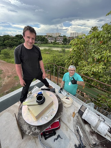
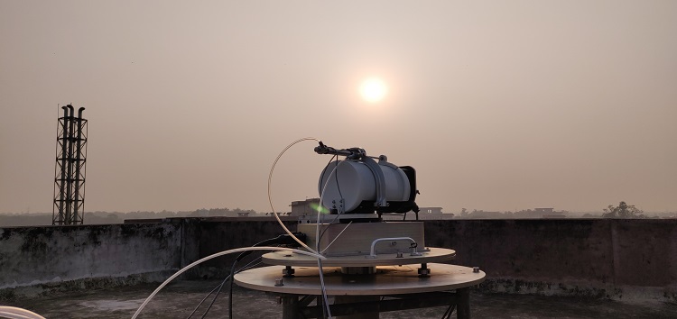
The Réunion Island site, which contributed data to the present study, hosts instruments performing measurements of total column and in-situ surface concentrations of greenhouse gases operated by BIRA-IASB in collaboration with local partners (LACy and OSU-R) and LSCE (France). The in-situ measurements are part of the European ICOS (Integrated Carbon Observation System) and the total column measurements are part of the global TCCON (Total Carbon Column Observing Network) and NDACC (Network for the Detection of Atmospheric Composition Change). Last month BIRA-IASB installed new TCCON and NDACC instruments at Porto Velho (Amazon forest in Brazil) in collaboration with IFRO and INPE; this is currently the only TCCON station in the South American continent and will provide critical data from an undersampled region contributing to carbon cycle studies, satellite and model validation and future Global Stocktakes.
BIRA-IASB stations collecting this kind of column concentrations of greenhouse gas data for future studies will be located in:
• Réunion Island (started in 2011 – , long term)
• Porto Velho, Brazil (started in Feb 2023 – , long term)
• Kolkata, India (started in Jan 2023 – , campaign based)
• Belgium (planned 2023)
• Democratic Republic of Congo (planned 2024 – , campaign based)
These stations will contribute to the Copernicus’ CO2SMVS (CO2 Monitoring and Verification System), Europe’s efforts to keep an eye on the global CO2 budget through a network of ground stations, satellites and atmospheric modelling.
Hopefully, the scientific data that our researchers are endeavoring to gather will help policy makers to keep the world on track for our climate goals.

Credit: Mahesh Kumar Sha (BIRA-IASB)
Contact
Lucie Lamort
Communication officer BIRA-IASB
lucie (dot) lamort (at) aeronomie (dot) be
Karolien Lefever
Head of Communication and Documentation BIRA-IASB
karolien (dot) lefever (at) aeronomie (dot) be
Credit: Helen-Nicole Kostis and Greg Shirah (NASA's Scientific Visualization Studio)
Credit: Helen-Nicole Kostis and Greg Shirah (NASA's Scientific Visualization Studio)


